Wli Falls: a forest walk near Hohoe
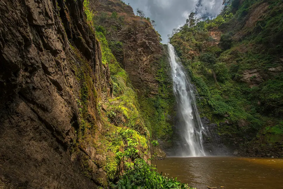
A short forest walk near Hohoe leads to twin falls in the Agumatsa hills, where fruit bats hang on the cliffs and the lower pool invites a paddle. Allow half a day.
- Region
- Volta Region, near Hohoe
- Falls
- Lower and upper falls
- From Accra
- About 280 km by road
- Wildlife
- Fruit bats on the cliffs
What Wli Falls is
Wli Falls sits in the hills behind Wli village, near Hohoe in the Volta Region, close to the border with Togo. The Agumatsa stream leaves the forest and drops over a rock face in two stages: a lower fall that most visitors reach on foot, and an upper fall further up the valley. The Ghana Tourism Authority calls Wli the highest waterfall in West Africa, a claim worth treating as a description rather than a measurement.
The cliffs beside the lower fall are the daytime roost of a colony of fruit bats, which hang in the open on the rock and stir as the afternoon cools. The forest around the stream holds birds and butterflies, and the walk in is as much about the shade and the trees as the water. The pool below the fall is the natural end point for most visits. Bring more time than the walk alone needs; sitting by the water is the point of the trip.
The walk to the lower falls
From the trailhead the path follows the Agumatsa through farmland and then forest, crossing the stream on simple bridges. The going is gentle for most of the way, with roots, mud and wet stone underfoot once the trees close in. There is no long climb to the lower fall, which makes the walk suitable for most ages, though the humidity does more of the work than the gradient. Allow a slow pace and stop where the path opens over the water.
At the fall the rock wall rises above a shallow pool, with spray in the air and bats overhead on the cliff. Swimming is possible when the water is low; after heavy rain the current is stronger than it looks, so take advice from the guide before going in. The upper fall lies beyond, on a steeper and rougher path that takes longer and is best attempted with someone who knows the route. Few visitors go beyond the lower fall, so the upper valley stays quiet.
Tip: Wear shoes with grip. The stones at the fall stay wet and the trail turns muddy after rain, so sandals are a poor choice.
Getting to Wli Falls
Wli is about 280 km from Accra by road, most of it on the surfaced highway to Ho, then north past Hohoe into the hills. Ho is the largest town on the route and the usual place to break the journey. The final stretch from Hohoe to Wli is a minor road that can be rough, and the surface varies with the season, so ask locally before setting out. Buy fuel and water in Hohoe; options thin out closer to the falls.
Trotros and coaches run between Accra and Ho throughout the day, and shared minibuses continue from Ho to Hohoe. From Hohoe, take a shared taxi or trotro toward Wli and ask to be set down at the falls turning; the last part may need a taxi hired for the day. Transport patterns change, so confirm the return leg when you arrive rather than at the end of the walk. Driving yourself is straightforward in daylight, and parking is close to where the path begins.
- Coach or trotro from Accra to Ho, then a shared minibus north to Hohoe.
- From Hohoe, a shared taxi or trotro toward Wli; ask for the falls turning.
- With your own vehicle, drive the Hohoe road in daylight and expect the last stretch to be unmade.
- Arrange the return journey in the morning, since afternoon transport toward Ho thins out.
When to go and how long
The Volta Region lies in Ghana's southern band, with rains roughly from April to June and again from September to November; the rest of the year is drier. The flow over the falls follows that pattern, heavy late in the rains and lighter in the dry months. The harmattan, a dry dusty wind, reaches the south in a milder form around December to February. Roads are easier in the dry season, and the trail is less slippery.
Half a day is enough for the drive from Hohoe, the walk to the lower fall and time by the pool. Add the upper fall and the visit stretches to most of a day. Start early, both to walk in cooler air and to be off the road before dark, which is when driving outside towns is best avoided. Mornings are cooler and the bats are still settled on the rock.
Tip: Check the flow before committing to a long detour: the falls are at their fullest late in the rains, when the trail is wettest. Ask in Hohoe about current conditions.
Nearby: Tafi Atome and Afadja
The Tafi Atome Monkey Sanctuary lies a short detour off the Hohoe road and protects a group of Mona monkeys held sacred for about 200 years. Community protection began in 1996, and the population is about 200. Guides lead visitors in on foot; the monkeys are wild but accustomed to people, so keep food out of reach and follow the guide's instructions. It pairs well with Wli in a single day out from Hohoe.
Mount Afadja, in the Agumatsa Range on the Togo border, reaches 885 m. The Ghana Tourism Authority calls it one of the highest points in the country and notes that nearby Aduadu is over 900 m, so it is a summit walk rather than a record. Routes up are steep in places; take a local guide and start early. Hohoe and Ho are the nearest towns for food and fuel.
Practical tips for the visit
Dress for humidity: light long trousers and a long-sleeved shirt keep insects off and dry faster than denim, and a change of top is welcome after the walk. Footwear with grip matters more than anything else, since the stone near the fall is slick. A hat and drinking water make the trail comfortable, and insect repellent is worth carrying for the forest sections. Bags stay drier in a plastic sleeve.
Photography is awkward in the middle of the day, when bright sky above the gorge and deep shade below confuse a meter; expose for the water and let the cliff go dark. Wipe the lens often, as spray carries. Local guides usually meet visitors at the entrance and lead the walk; agree the route and the time before setting off. An entry fee applies, and arrangements are best checked in Hohoe or with the Ghana Tourism Authority.
- Quick-drying clothing and a spare shirt, since the humidity leaves cotton damp.
- A plastic sleeve or dry bag for phone and camera near the spray.
- Water and a snack, as the walk and the heat take more out of you than expected.
- Insect repellent for the forest stretch, particularly after rain.
Frequently asked questions
How do you reach Wli Falls from Accra?
Wli Falls is about 280 km from Accra by road, with most of the journey on the highway to Ho and then north past Hohoe. Coaches and trotros cover the Accra to Ho leg, shared minibuses continue to Hohoe, and a shared taxi or hired car takes you the last stretch toward Wli. The final road can be rough, so confirm the return trip before you set off.
Is the walk to Wli Falls difficult?
The walk to the lower fall at Wli Falls is gentle for most of the way, with no long climb, though the path crosses the stream on simple bridges and carries roots, mud and wet stone. The humidity is the real challenge. The upper fall is a steeper, rougher and longer walk, and is best attempted with a local guide.
When should you visit Wli Falls?
The driest months make the trail to Wli Falls easiest underfoot. Ghana's south has rains roughly from April to June and September to November, and the falls run heaviest late in those periods, when the path is muddiest. The harmattan brings dusty, hazy air around December to February. Check conditions in Hohoe before travelling.
Are there fruit bats at Wli Falls?
A colony of fruit bats roosts on the cliffs beside the lower fall at Wli Falls, hanging in the open during the day and stirring as the afternoon cools. They are the reason many visitors linger at the pool. Keep noise down, do not try to touch them, and let a guide advise on where to stand for a clear view.
Can you swim at Wli Falls?
There is a pool below the lower fall at Wli Falls, and a paddle or a short swim is possible when the water is low. After heavy rain the current is stronger than it looks, so ask a guide before going in. Most visitors settle for cooling off at the edge of the water.
Do you need a guide at Wli Falls?
Local guides usually meet visitors at the entrance to Wli Falls and lead the walk, and an entry fee applies. Agree the route and the time before setting off, particularly if the upper fall is part of the plan. Arrange the visit in Hohoe or check with the Ghana Tourism Authority, since arrangements change.
Is Wli Falls the highest waterfall in West Africa?
The Ghana Tourism Authority describes Wli Falls as the highest waterfall in West Africa. Published heights and rankings for waterfalls vary, and the claim is best treated as a description of scale rather than a measurement. The falls carry most water late in the rains, whatever the ranking says.
How long does a visit to Wli Falls take?
Half a day covers the walk to the lower fall at Wli Falls, time by the pool and the return to Hohoe. Adding the upper fall stretches the visit to most of a day. Start in the morning for cooler air and to be off the road before dark, when driving outside towns is best avoided.
Read next
IMPT Ghana editorial team · Reviewed 13 November 2026. Facts checked against the Ghana Tourism Authority (visitghana.com), the Ghana Immigration Service and other official sources listed in our editorial policy. Prices are never shown: live rates open in the IMPT app.
Find a stay in Hohoe
Photo credits: Kradolferp, CC BY-SA 4.0, via Wikimedia Commons.