Lake Bosomtwe: A Crater Lake in Ashanti
A meteorite crater lake ringed by forested hills, roughly 31 km from Kumasi. Come for the water, the cycling and the quiet, and allow a full day.
- Region
- Ashanti Region, Ghana
- Distance
- About 31 km from Kumasi
- Depth
- About 70 to 73 m
- Status
- UNESCO biosphere reserve
A crater lake in Ashanti
Lake Bosomtwe lies in the Ashanti Region, roughly 31 km from Kumasi. It fills a meteorite impact crater, which makes it Ghana's only true natural inland lake. Forested hills form the rim, and the lake has no surface outlet, so water leaves by seepage and evaporation. It covers about 49 km² and is about 70 to 73 m deep. UNESCO lists it as a biosphere reserve, and that status shapes how the shoreline and the surrounding forest are used.
The crater is ancient, and the lakebed has been cored for what its sediments record about the region's past climate. For visitors the practical effect is simple: this is a working landscape, with villages, farms and fishing along the shore rather than a resort strip. Boats are shaped from single planks of wood, and the shoreline path passes homes, small plots and landing points. Treat the lake as somewhere people live and work, not only as a view.
What to see around the shore
The rim is the main sight. Forest closes in on the approach, then the hills open and the water appears below. Stopping at the viewpoints on the way down is part of the visit, and the light is best early and late in the day. Villages ring the shore, with Abono the best known and the usual arrival point on the eastern side. Ask before walking through farmland, between compounds or past shrines.
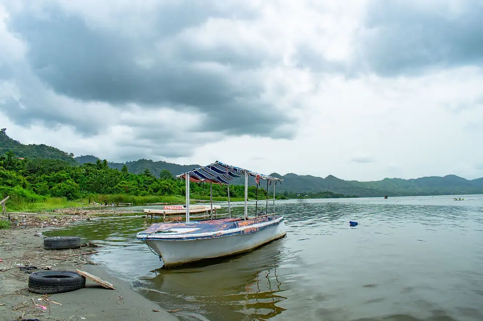
Birdlife follows the forest edge, and the hillsides hold remnants of the original woodland among farms and regrowth. Walking the shoreline path takes you past landing points where plank boats are moored and where people wash, fish and swim. The crater wall makes a steep, hard backdrop on every side. The lake is sacred in local tradition, with rules that vary between villages, so follow a guide's advice on where to walk and when.
- The crater rim: steep forested hills that give the wide view back over the water.
- Shoreline villages, with landing points and plank fishing boats drawn up on the sand.
- Forest-edge birdlife, easiest to see in the early morning before the heat builds.
- Local farmland and footpaths, walked with permission and a guide.
Swimming, cycling and walking
Swimming is possible from the shore in calm weather, and local people swim in the lake. There are no lifeguards, the bed shelves away quickly in places, and the middle is deep, so keep to the shallows where others are already in the water. Ask where you are staying about the safest stretch. Never swim alone, keep children within reach, and leave the water if the weather turns.
Cycling and walking are the other ways to see the crater. The descent to the water is steep and the rim road rolls up and down, so a short circuit suits most riders better than a lap of the whole lake. Mountain bikes can be arranged locally. Walking the shoreline path is easier on the legs, though it narrows between farms and compounds. Start early, before the heat builds in the crater.
Tip: Hire a local guide for walks and rides: tracks between farms are not marked, and permission matters here. Agree the route and the day before you set out.
Getting there from Kumasi
The lake is about 31 km from Kumasi in a straight line, and further by road. Kumasi's airport sits about the same distance from the water as the city centre. Most visitors come by private car or taxi, or take a shared minibus towards the lakeside villages and walk the final stretch. The last descent to the shore is steep, and the surface can be rough after rain.
Shared minibuses leave from Kumasi's stations through the morning and fill as they go, so a wait is normal. Roads are busiest at the start and end of the working day. Travel after dark outside towns is best avoided, and that applies to the descent to the lake, which has no lighting. A vehicle with decent clearance helps on the last section. Bring water for the wait.
Tip: Ask your host or a local driver about the descent after heavy rain, and plan to be back in Kumasi before dark.
When to go and how long
The south has two rainy seasons, roughly April to June and September to November, and the harmattan haze drifts down from about December to March. Rain makes the descent to the shore slippery and the water less inviting, but the hills are greenest then. Drier months give clearer views across the crater. Weekends and public holidays are busier, when visitors drive out from Kumasi for the day. Mornings are calmer and cooler.
A day trip covers the view, a swim and a short walk, but the drive takes a large part of the day and the return is slower. One night by the water suits anyone who wants early light on the crater. Two days lets you pair the lake with Kumasi: the Manhyia Palace Museum, Kejetia Market, and the kente villages at Bonwire and Adanwomase.
Where to stay nearby
Lakeside stays sit in and around the villages on the shore, from simple guesthouses to places with rooms facing the water. Abono is the usual base on the eastern side, and other villages have quieter stretches of shore. Kumasi has the widest choice if you prefer a city base, though it adds a drive in each direction. Book ahead for weekends and public holidays, and confirm the final approach with your host, since the descent is steep and unsurfaced in parts.
Dress modestly away from the water: shorts and swimwear belong at the shore, and covered shoulders and knees are the safer choice in villages. The crater holds the heat, so carry water, a hat and sun protection, and plan the hardest walking for the morning. Cash in cedis is useful, as card payment is unreliable away from Kumasi. Mobile coverage is patchy in parts of the crater, so download anything you need before leaving the city.
Photography is best in the early morning, when light comes over the rim and the water is still. Ask before photographing people, homes or shrines, and accept a refusal without argument. Guides can be found at the main landing points, and a good one will explain local customs and which paths are open. Some areas close for traditional reasons on certain days. Keep the shoreline path clear for people carrying loads, and greet people as you pass.
- Wear shoes with grip for the steep descent and the shoreline path.
- Carry water and sun protection, as the crater holds the heat of the day.
- Ask before photographing people, homes or shrines, and accept a no politely.
- Keep to the shallows when swimming, and never swim alone.
Frequently asked questions
How far is Lake Bosomtwe from Kumasi?
Lake Bosomtwe lies roughly 31 km from Kumasi in a straight line, and the road distance is longer because the last stretch drops down the crater rim. Most visitors allow more time than the distance suggests, especially leaving the city in the morning traffic. Ask locally about the descent after heavy rain.
Can you swim in Lake Bosomtwe?
Yes. Local people swim from the shore, and visitors do the same in calm weather. There are no lifeguards, the bed shelves away quickly in places, and the middle is deep, so stay in the shallows where others are already in the water. Never swim alone, and ask your host which stretch is safest.
How was Lake Bosomtwe formed?
A meteorite struck the site and left a crater, which filled with water to form the lake. It has no surface outlet, so water is lost through seepage and evaporation. The lake covers about 49 km² and is roughly 70 to 73 m deep. UNESCO recognises it as a biosphere reserve.
When should you visit Lake Bosomtwe?
The drier months give the clearest views across the crater, though harmattan haze drifts in from about December to March. The south has two rainy seasons, roughly April to June and September to November, when the descent gets slippery. Weekdays are quieter than weekends and public holidays, when visitors arrive from Kumasi.
Do you need a guide at Lake Bosomtwe?
Not for the main viewpoints, but a local guide helps on footpaths between farms and villages, where routes are unmarked and permission matters. Guides are usually available at the landing points. Agree the route before setting out, and remember that some places and days carry traditional restrictions.
Should you stay overnight at Lake Bosomtwe?
A day trip covers the view, a swim and a short walk, but the drive eats into the day. Staying one night gives early light on the crater and a slower pace, and two days lets you add Kumasi's museum and market to the trip. Book ahead for weekends and public holidays.
What should you take to Lake Bosomtwe?
Water, a hat and sun protection, because the crater holds the heat. Shoes with grip suit the steep descent and the shoreline path. Bring swimwear for the water and a modest layer for villages, where covered shoulders and knees are the safer choice. Carry cedis for small purchases.
Can you cycle around Lake Bosomtwe?
Cycling the rim road is possible but undulating, with steep sections down to the shore, so a short circuit suits most riders better than a full lap. Mountain bikes can be arranged locally. Check the brakes and tyres on anything you hire, and start early to avoid the heat of midday.
Read next
IMPT Ghana editorial team · Reviewed 13 November 2026. Facts checked against the Ghana Tourism Authority (visitghana.com), the Ghana Immigration Service and other official sources listed in our editorial policy. Prices are never shown: live rates open in the IMPT app.
Find a stay in Bosomtwe
Photo credits: Amuzujoe, CC BY-SA 4.0, via Wikimedia Commons.